
Research
Graduate Research
M.S. Project @University of Idaho:
Project description: My M.S. research project focused on evaluating methods of detecting forest insect damage and mortality using Unmanned Aerial Systems (UAS)-derived data products in conifer forests of the western United States. The project explored the utlity of point cloud data derived from Structure for Motion (SfM) for the classification and characterization of vertical tree damage of a UAS mission area. I used tools such as ArcGIS Pro, Agisoft Metashape, CloudCompare, and R and Python programming to create new algorithms and establish a novel methodology.
Drone data used for this MS thesis was collected for a broader project assessing tree damage funded by the NASA Commercial SmallSat Data Acquisition Program (NASA CSDA, award #80NSSC21K115) (see ‘Collaborative Research’ section below).
The research for this project was conducted in the ancestral homelands of the Ksanka (Kootenai), Ql̓ispé (Pend d’Oreille), and Sélish (Salish) tribes of western Montana.
A DJI Matrice 210 drone equipped with a MicaSense RedEdge-MX sensor (5-band calibrated sensor) from Washington State University’s Forest Ecosystem Dynamics Lab (research partners) was used for imagery acquisition. UAS image acquisition mission was planned and operated by Dr. Amanda Stahl. Here preview of the UAS-photogrammetry derived point cloud data I am working with (data is displayed on CloudCompare):
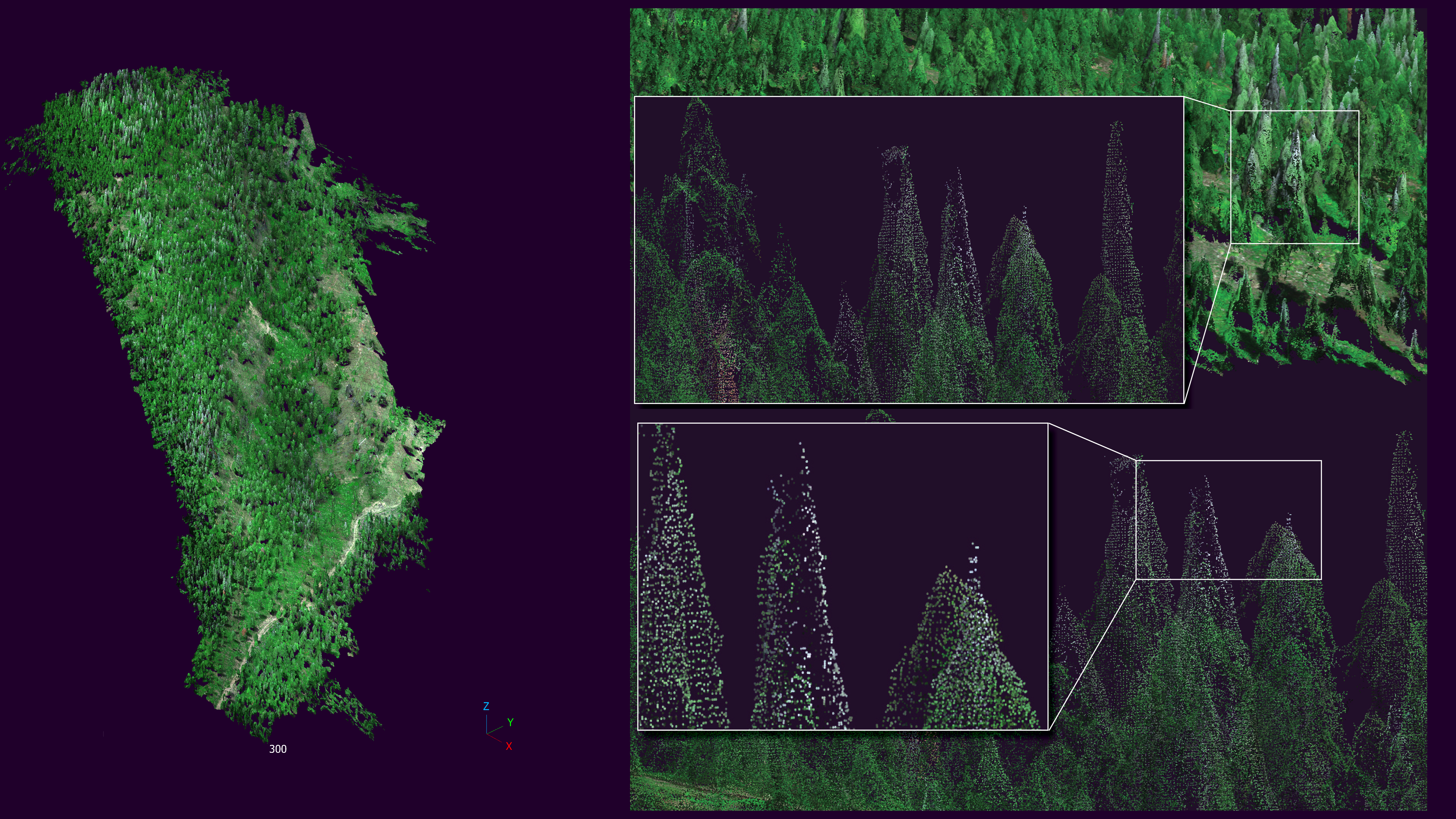
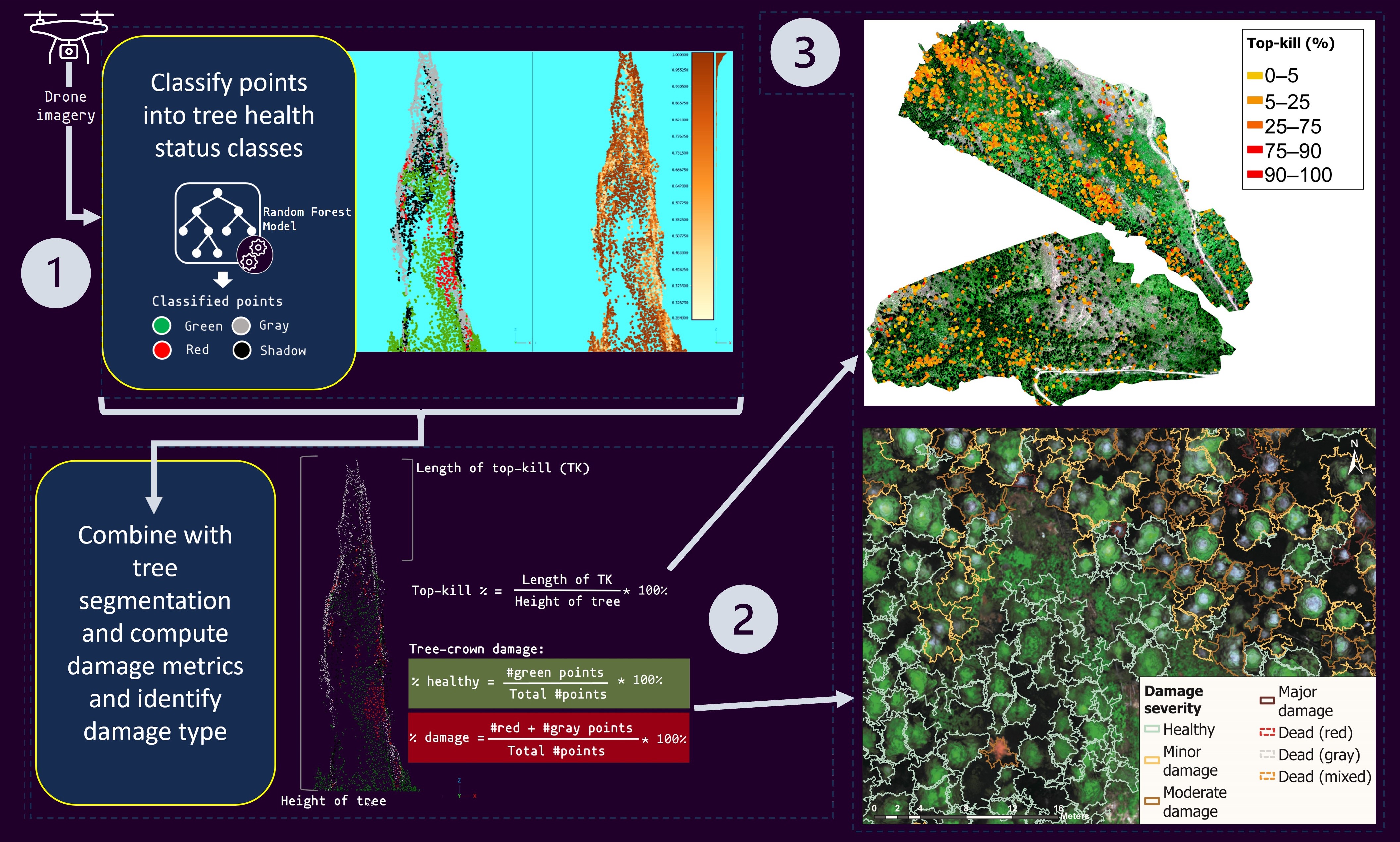
I am currently developing the journal article for my project. In the meantime, checkout the graphical abstract for the journal article in preparation for this project and example data product from the methodlogy applied on the point cloud of a single tree
Graphical abstract
Journal article:
Interactive preview of methodology applied on the point cloud of a single tree
Use the left mouse button to tilt the 3D model and the mouse scroll wheel to zoom in and out.
True-color render and random forest classification of point cloud
Left panel: True color representation of the point cloud. Right panel: RF classification; green is healthy, red is red, gray is gray, and black is shadow.
Random forest classification probability and top-kill algorithm
Left panel: The probabilities of classes shown in left panel on the above interactive layout; darker colors represent higher probabilities of classification. Right panel: Top-kill algorithm applied to point cloud, 3D plane represents the height of top-kill detected by the algorithm.
I presented a condensed version of my MS research for University of Idaho’s GIS day 2023 as a contributed talk.
To view the recording of the presentation, please follow this link:
To view the pdf of the presentation file, please follow this link: https://objects.lib.uidaho.edu/gisday/shrestha_gisday2023.pdf
Collaborative research:
Graduate Research Assistant, NASA Commercial SmallSat Data Analysis (NASA CSDA) project
Project title: Using commercial satellite imagery to study insect outbreaks in the US: Outbreak characteristics and evaluation of Landsat-based algorithms.
Project decription: This is a collaborative research project with researchers from the University of Idaho, Washington State University, and the US Forest Service Rocky Mountain Research Center.
Principle Investigator: Dr. Arjan Meddens, School of the Environment, Washington State University, Pullman, WA
Responsibilities:
- conduct collaborative research to develop machine learning image classification algorithms (RF, MLC, NN) that assess forest mortality using high-resolution satellite imagery
- assist field crew with forest inventory data collection (FIA-based)
- create and maintain spatial databases; perform logistics mapping
- execute drone imagery acquisition missions
Collaborative Researcher, UAV-based rangeland project
Principle investigator: Georgia Harrison
Faculty advisor: Dr. Jason Karl
Project title: A comparison and development of methods for estimating sagebrush shrub volume.
Journal article:
Project description: This project is funded by the Joint Fire Science Program’s Graduate Research and Innovation (GRIN) Fellowship secured by PI Georgia Harrison, Department of Plant Sciences, University of Idaho and is a part of her PhD dissertation.
Responsibilities:
- develop workflow of estimating shrub canopy volume with 3D data from drones by modifying currently available forestry-based remote sensing tools and techniques
- use Git and GitHub for collaborative code sharing. GitHub repository URL: https://github.com/gharrison159/UAVShrubVolume
Here is an interactive preview of the shurb delineation and segmentation on a subset of the data for this project:
Use the left mouse button to tilt the 3D model and the mouse scroll wheel to zoom in and out. Individual colors represent segmented shrub.
Publications
Shrestha, A.; Hicke, J.A.; Meddens, A.J.H.; Karl, J.W.; Stahl, A.T. Evaluating a Novel Approach to Detect the Vertical Structure of Insect Damage in Trees Using Multispectral and Three-Dimensional Data from Drone Imagery in the Northern Rocky Mountains, USA. Remote Sensing, 2024, 16, 1365. https://doi.org/10.3390/rs16081365
Harrison, G. R., A. Shrestha, E. K. Strand, J. W. Karl, A comparison and development of methods for estimating sagebrush shrub volume using drone imagery-derived point clouds, Ecosphere 2024. https://doi.org/10.1002/ecs2.4877
Hicke, J. A., B. C. Bright, R. P. Hanavan, A. T. Hudak, A. J. H. Meddens, A. Shrestha, A. T. Stahl, A review of remote sensing of forest insect and disease outbreaks: Bottom-up and top-down considerations for detection and attribution, (under review), 2024
Theses & Dissertations
Shrestha, A., Combining Multispectral and Three-Dimensional Data From Drone Imagery to Detect Forest Insect Damage: An Evaluation of a Novel Approach to Identify the Vertical Structure of Damage in Trees in the Northern Rocky Mountains, USA. MS thesis. University of Idaho, Moscow, ID, December 2023.
Shrestha, A., GIS-Based Study on Topographical Preference of Common Tree Species in Palisades-Kepler State Park, IA, honors thesis, Coe College Department of Biology, Cedar Rapids, IA, May 2019.
Presentations
Shrestha, A., J. A. Hicke, A. J. H. Meddens, J. W. Karl, A. T. Stahl, Evaluating the combination of reflectances and three-dimensional point cloud from drone imagery for detecting forest insect damage, contributed talk, University of Idaho GIS Day, November 2023.
Harrison, G. R., A. Shrestha, JW. Karl, “Seeing shrubs from the sky: an exploration of using drone-based method to estimate shrub canopy volume”, contributed talk, Ecological Society of America (ESA) Annual Conference, 6-11 August 2023, Portland, OR.
Hicke, J. A., A. Shrestha, A. Meddens, A. Stahl, B. Bright, A. Hudak, R. Hanavan, “Using Remote Sensing to Study Tree Damage from Insects”, keynote speaker, Western Forest Insect Work Conference (WFIWC), 25-27 April 2023, Seattle, WA.
Shrestha, A., & Sanchini P. “A Geographic Information System (GIS)-based study on topographical preference of common tree species in Palisades-Kepler State Park”, contributed talk, Coe College Student Research Symposium, Coe College, Cedar Rapids, IA, 2019.
Obiesie, C., Shrestha, A., & Sanchini, P. “Distribution of Oaks (Quercus spp.) in Forests of Palisades-Kepler Park, Linn County, Iowa”, poster presentation, Coe College Student Research Symposium, Coe College, Cedar Rapids, IA, 2019.
Yoshida, K., Shrestha, A., & Chihak, B. “How Roadway Design Affects Cyclist-Motorist Interactions”, poster presentation, Tri-State Undergraduate Psychology Research Conference, Loras College, Dubuque, IA, 2018.
GitHub Repositories
Drone shrub volume project
- Pricipal investigator: Georgia Harrison.
GitHub:
- Zenodo:

Point cloud classification and top-kill assessment
- Principle investigator: Abhinav Shrestha
- GitHub:
University of Idaho R-Programming course (ENVS 511)
Course GitHub repository (
MAIN):- Final project repository:
- Website URL: https://rpubs.com/abhinav-shrestha/979241
- R-Shiny web app repository (online dashboard; click image below to visit):

Previous Research
GIS-based study of topographical preference of common tree species in Palisades-Kepler State Park, IA
(Senior Honors Thesis, Coe College, Cedar Rapids, IA, 2019)
Abstract: The study seeks to develop an understanding of the topographic characteristics that influence tree species composition of upland forests at Palisades-Kepler State Park, Linn County, Iowa. The role of Quercus alba, white oak, is a focus of this study. 123 plots containing 706 trees were sampled with the use of GPS receivers and field methods in the summer of 2017. The sampled field data were combined with its respective GPS data, and mapped on Digital Elevation Model imagery. Geographic Information System (GIS) analyses are used to develop a model of sites suitable for oak regeneration and maintenance within this forest.
Research blog URL: https://oaksatpalisades.home.blog/
Thesis info URL: https://coecollege.on.worldcat.org/oclc/1137317800
Distribution of Oaks (Quercus spp.) in Forests of Palisades-Kepler Park, Linn County, Iowa
(Poster Presentation, Coe College Student Research Symposium, Cedar Rapids, IA, 2018)